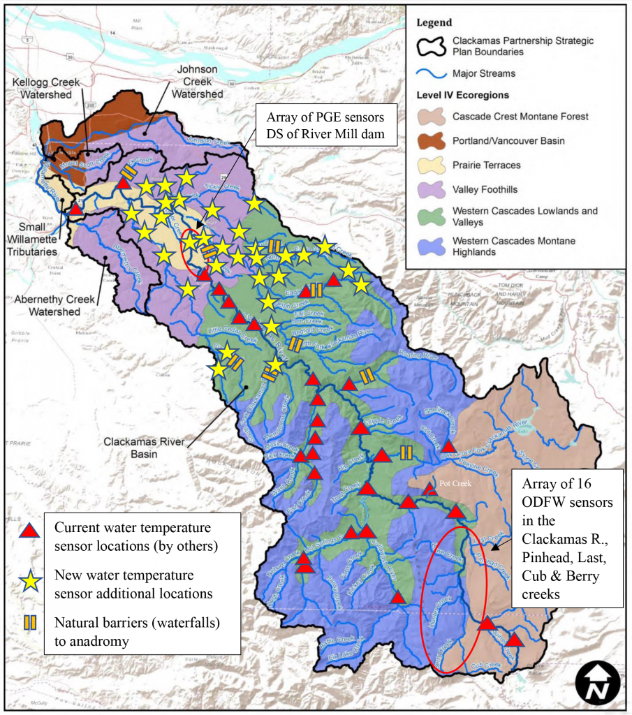
Summary: To monitor water temperatures on a continuous basis in the Clackamas River basin (mainstem and tributaries) at 80 selected sampling locations utilizing data loggers/sensors between June and October, 2021, 2022 & 2023. Data will be collected and analyzed at the end of each season, culminating with a set of findings and recommendations in 2024.
Project Start Date: April 21, 2021.
Project End Date: June 30, 2024
Project Overview: The principal goal of this study will be to determine the spatial and temporal heterogeneity of water temperatures within the basin. Specifically, how it relates to the abundance and composition of the native fish community. Knowing sources of cold water in the basin will aid in determining the likely or preferred distribution of fish during their spawning and rearing life stages. In a general sense, this information can be used to identify strategic actions to protect, enhance and restore, where possible, thermal habitat and cold water refuges. Actions identified and implemented are important for optimal climate resiliency and stewardship for this basin, which provides drinking water for 10% of Oregon’s population and is important for salmon recovery within the Willamette River and Lower Columbia River basins. On average, rearing salmonids and other cold water species will tend to seek out the coldest and otherwise most conducive habitat; therefore, this study will also aid in fish habitat restoration measures to allow planners to place such efforts where the fish are most likely to be, both now and in the future, thus maximizing benefit-to-costs ratios. As climate change continues, locating reliable sources of cold water (on a larger scale) will aid in developing public policy to implement protection measures to ensure, in a relative sense, that such sources will remain.
Work completed to date: The first season’s data collection (2021) is complete and data is currently being analyzed.
Total Project Cost: $98,150
In-kind Contributions and Funds committed to date: $76,150
Funds Left to Raise: $22,000
Work to be performed by Portland State University (PSU): Spatial and temporal heterogeneity analyses incorporating spatial-statistical stream network modeling tools for river systems utilizing data from the water temperature loggers for the Clackamas River basin. The PSU temperature model will develop a set of high-resolution (1 kilometer) digital maps that represent present climate using data collected in 2021 (Phase 1). In Phase 2 of the project, with an additional two years of data collection (2022 and 2023), the PSU model will first be calibrated with these data and then be used for simulating future water temperatures under a suite of representative future climate change scenarios.
How this effort differs from previous studies:
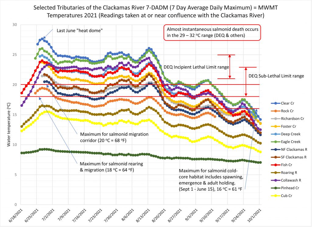
- The June 2021 heat dome, the hottest in recorded history, was captured by this temperature sensor array and is a fundamental calibration tool for the Phase 2, predictive, climate-related studies. This has never been simultaneously captured before to such a basin-wide extent, uncovering how disparate areas responded to this sudden increase in temperature.
- PSU will combine this water temperature data with their climate model of the basin, recently completed, thus further refining, and creating a more accurate predictive tool for expected changes in water temperature over time.
- This study will incorporate other data to understand how the basin responds over time to the effects of the 2020 Riverside Fire, which affected about 138,000 acres and significantly diminished tree canopies, thus increasing water temperatures, among other effects.
- This largest array (in terms of geographical extent and simultaneity) of water temperature sensors has been, and will be, employed to develop the most accurate water temperature suite of models in the basin’s history, serving as a model for the entire state.
Project Objectives: To depict in the present day, and to predict in the future, how the water temperatures within the Clackamas River Basin vary in both spatial and temporal respects. The thermal maps that will be created by PSU will depict such changes that are easily understandable to all: from the general public to researchers. Other data, whether in tabular or graphical forms, will also be produced for those who want to use the data for other purposes, integrating other metrics, such as how these thermal regimes overlap with water flow rates, areas with high intrinsic potential, water quality, future development, etc. The applications are many.
Project Partners: Many partners have come forward to support this project, whether to provide water temperature data, funding, sensors, or expertise: Oregon Department of Fish & Wildlife (sensors and expertise), Portland General Electric (sensors and data), Clackamas County Water Environment Services (data), US Forest Service (data), US Geological Survey (data), and the US Fish & Wildlife Service (sensors and data), Trout Unlimited (sensors), Clackamas River Water Providers (funding).
Equally as important is the cooperation of 21 private, rural landowners who have given their permissions to access and place sensors within water courses that flow through their properties. Two families and Port Blakely have also sponsored the purchase of a number of sensors that were/will be placed on their properties and elsewhere in the basin.
Maps & Graphs: