[vc_row][vc_column][rescuepress_banner][/vc_column][/vc_row][vc_row css=”.vc_custom_1505800637172{padding-top: 50px !important;padding-bottom: 50px !important;}”][vc_column][vc_row_inner el_class=”container”][vc_column_inner][vc_column_text]
CROSSING CL058B
Clear and Foster Creek 2002 Fish Passage Assessment
Watershed: Clear Creek
Stream: T Moiser
Road: Lower Highland
Latitude: 45.2622509667
Longitude: -122.4398802247
Elevation: 1062 ft
Ownership: Private
Fish Presence: fish present
Survey date: 07/10/2002
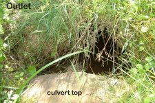
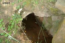
Crossing Description
Type: round culvert
Condition: +5.0 years left
Diameter: 24.0 in
Length: 30.0 ft
Crossing slope: 0.9 %
Avg. embedded: 8.3%
Type of embedding: simulated streambed
Embedded material: fines
Inlet design: non-mitered
Backwater drop: – 0.2 ft
Inlet elev: +0.1 ft
Avg. fill height: 2.8 ft
Road width: 11.0 ft
Habitat Description
Channel habitat type: moderate gradient, moderately confined
Catchment acreage: 229
Avg. channel slope: 0.2%
Avg. bankfull width: 3.1 ft
Dist from Clackamas R.: 16.4 miles
Upstream fish-bearing length: 3791.7 ft
Dominant channel substrate: none recorded
Comments: Landowner says she had fish in creek historically. Solution – Much of downstream end of culvert is backwatered. Embedded round culvert 40 ft long.
Prioritization and Cost Information
Fish passage: partial
Habitat priority: 52
Habitat and cost priority: 29
Fix solution: culvert w/ simulated streambed
Span: 4.0 ft
Material: metal
Design $2,200
Materials $2,740
Install $5,050
Contingencies $2,997
Total $12,987.00
[/vc_column_text][/vc_column_inner][/vc_row_inner][/vc_column][/vc_row]