Where We Work
The Clackamas watershed is a special place. It is home to the last significant run of wild late winter coho in the Columbia Basin, and it is also one of only two remaining runs of spring Chinook in the Willamette Basin. In addition, it supports a significant population of winter steelhead. The watershed is also home to threatened and endangered species, including the peregrine falcon, bald eagle, and Nelson’s checkermallow.
20 miles of the Clackamas are classified as seasonal, and 27 are classified as recreational, for a total of 47 miles of wild and scenic river. In order for a river to become a National Wild and Scenic River, it mus have at least one resource that is considered to be “outstandingly remarkable.” Assessment of the Clackamas River found five different resource categories to be “outstandingly remarkable” — recreation, fish, wildlife, historic, and vegetation.
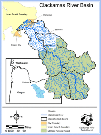
The Clackamas Watershed is made up of a series of diverse and resource-rich subwatersheds. Visit each subwatershed page for more information:
Clear Creek Deep Creek Eagle Creek Goose Creek Richardson Creek Rock Creek Mt. Hood National Forest
- For interactive maps of the fish passage barriers at Deep, Goose, and Eagle Creeks, click here.
- For interactive maps of the barriers on Clear and Foster, click here.