[vc_row][vc_column][rescuepress_banner][/vc_column][/vc_row][vc_row css=”.vc_custom_1505076577885{padding-top: 50px !important;padding-bottom: 50px !important;}”][vc_column][vc_row_inner el_class=”container”][vc_column_inner][vc_column_text]
CROSSING EG008
Deep, Goose, Eagle 2004 Fish Passage Assessment
|
| Watershed: Eagle Creek |
Stream: Currin Creek |
Road: SE Frog Pond Ln |
| Latitude: 45.33798008 |
Longitude: -122.3582829 |
Elevation: 329 feet |
| Ownership: County |
Fish Use: Anadromous |
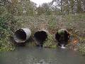
Type: Round metal culvert pipes (3) |
| Slope: LB: 1.7% Center: 1.7% RB: 1.2% |
|
Habitat Description
|
| Channel habitat type: Low gradient |
Catchment acreage: 3,436 |
| Avg. bankfull width: 21 feet |
Distance from Clackamas R.: 1.9 miles |
| Upstream fish-bearing length: 10.9 miles |
|
| Comments: This crossing on a privately maintained road is a partial barrier on lower Currin Creek with three culverts. One of the three culverts (all culverts = 5′ dia. CMP) is a complete barrier and the other two are partial barriers because of a high outlet jump height and steep culvert slope |
Prioritization and Cost Information
|
| Degree of fish passage blockage: Partial |
Habitat priority: 6 |
Habitat and cost priority: 20 |
| Fix solution: Bridge |
Span: See details ft |
Rise: n/a ft |
| Length: 42 ft |
Fill Height (ft): 7 ft |
Utilities concerns: Probably has UG utilities passing over |
| Traffic volume: Light, but daily |
Total Estimated Project Cost: $260,000
|
|
Field Photos
|
 |
[/vc_column_text][/vc_column_inner][/vc_row_inner][/vc_column][/vc_row]