[vc_row][vc_column][rescuepress_banner][/vc_column][/vc_row][vc_row css=”.vc_custom_1505076577885{padding-top: 50px !important;padding-bottom: 50px !important;}”][vc_column][vc_row_inner el_class=”container”][vc_column_inner][vc_column_text]
CROSSING EG009
Deep, Goose, Eagle 2004 Fish Passage Assessment
|
|
Watershed: Eagle Creek
|
Stream: Currin Creek
|
Road: SE Talons Rd
|
|
Latitude: 45.33403933
|
Longitude: -122.3529191
|
Elevation: 376 feet
|
|
Ownership: County
|
Fish Use: Resident
|
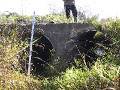
Type: Round metal culvert pipes (2)
|
|
Slope: RB: 0.6% LB: 0.8%
|
|
Habitat Description
|
|
Channel habitat type: Low gradient
|
Catchment acreage: 2,517
|
|
Avg. bankfull width: 7 feet
|
Distance from Clackamas R.: 2.3 miles
|
|
Upstream fish-bearing length: 10.4 miles
|
|
|
Comments: This crossing is a partial barrier on Talons Road over Currin Creek. It is a double culvert crossing with a high outlet jump and borderline culvert slopes. The crossing is not of adequate size to handle the seasonal flows and routinely backs up over the road. This site is combined with EG009B in the same spreadsheet. Crossing consists of two 48″ CMP.
|
Prioritization and Cost Information
|
|
Degree of fish passage blockage: Partial
|
Habitat priority: 18
|
Habitat and cost priority: 6
|
|
Fix solution: Culvert Stream Simulation
|
Span: 4 ft
|
Rise: ft
|
|
Length: 25 ft
|
Fill Height (ft): 0.88 ft
|
Utilities concerns: May have UG utilities; there are a few house located past this point
|
|
Traffic volume: Light, but daily
|
Total Estimated Project Cost: $23,000
|
|
|
|
[/vc_column_text][/vc_column_inner][/vc_row_inner][/vc_column][/vc_row]