CROSSING DPD01
Deep, Goose, Eagle 2004 Fish Passage Assessment
|
| Watershed: Deep Creek |
Stream: NF Deep Creek |
Road: n/a |
| Latitude: 45.42672632 |
Longitude: -122.3769929 |
Elevation: 468 feet |
| Ownership: County |
Fish Use: Anadromous |
Type: Wier |
| Slope: n/a |
|
Habitat Description
|
| Channel habitat type: Low gradient confined |
Catchment acreage: 6,991 |
| Avg. bankfull width: 33 feet |
Distance from Clackamas R.: 4.7 miles |
| Upstream fish-bearing length: 16.9 miles |
|
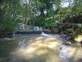
| Comments: This is a concrete weir maintained by a Clackamas County wastewater treatment facility outside of Boring on the North Fork Deep Creek. The County uses the weir to test water quality for permitting purposes. The 27 foot wide weir spans the creek just downstream of the bridge on Ritchey Road. The weir is a partial barrier to juvenile fish because of the jump height and the width of the cement barrier. In addition, the weir’s footing on each bank is eroding. |
Prioritization and Cost Information
|
| Degree of fish passage blockage: Partial |
Habitat priority: 3 |
Habitat and cost priority: 2 |
| Fix solution: Removal |
Span: n/a ft |
Rise: n/a ft |
| Length: n/a ft |
Fill Height (ft): None ft |
Utilities concerns: None |
| Traffic volume: None |
Total Estimated Project Cost: $13,000
|
|
Field Photos
|
 |